How to Thru-Hike the Enchantments
Located in the Alpine Lakes Wilderness, the Enchantments are home to arguably Washington State’s most beautiful lakes and mountains. The region has over 700 lakes, grand waterfalls, and rugged mountains.
Backpacking this region is so popular that the state started a lottery system for permits in 1987 (more on that here). Nowadays, getting permits to the Core Zone is one of the most competitive lotteries in the United States — and that’s where the thru-hike comes in.
Permits to day hike are unlimited and self-registered at the trailhead. If you have the stamina, strength, and determination you can see most of the Core Zone and Enchantments all in one day – no lottery winnings needed.
Click below to skip to a section.
Disclosure: We’ve included affiliate links with recommended hiking gear in this post. If you click through and buy something, we’ll receive a small portion of that sale. You won’t be charged more, and we haven’t been paid by any of these retailers to share their information. These are all our genuine preferences.

This map shows the permit zones throughout the Enchantments. We’ve marked each trailhead in blue and the route follows the dotted line between the two. Source: fs.usda.gov
Where to start your hike
There are two points you can begin your thru-hike, and the direction you choose will drastically change your hike. Both trailheads have pit toilets, do not allow camping, and do not have cell service.
The parking lots also fill up quickly. If you plan on arriving on a weekend, expect the lots to by 7:00 am and even earlier during the larch season in the fall. Do not park on the shoulders of the road with no parking signs as these areas are for emergency vehicles only.
The Stuart and Colchuck Lake Trailhead
Most thru-hikers start from here and finish their hike at the Snow Lake Trailhead. The drive there includes 20 minutes of pot-holed forest roads, but if you go slowly, any car can make it. Still, an SUV with all-terrain tires is best.
Beginning your hike here allows you to tackle the steepest terrain — Aasgard Pass — from the get-go. This is beneficial because your legs are still fresh and temperatures are cool. The downside to this approach is hiking the elevation loss. All 7,000 feet of it across 10 miles descending from the Core Zone. Even with patellar tendonitis (residual knee pain going downhill), this is Meghann’s preferred route.
Snow Lake Trailhead
If you feel so inclined, hiking from the Snow Lake lot to the Stuart/Colchuck lot isn’t unheard of. This lot sits right off the road, but it is smaller. Slow down as you near it so you don’t miss it!
Starting here does mean that you’ll be hiking down Aasgard instead of up, and at the hottest point of the day. If you do choose this route, I’d advise timing your descent before sunset — scrambling down, even with a headlamp, gives us pause (more on this below in the Aasgard section).

Selfie at the Snow Lake Trailhead after finishing our first thru-hike
Trail statistics
Starting at the Stuart and Colchuck Trailhead
Trail Description: Washington Trails/Alltrails
Distance: 18 miles
Elevation gain: 5,500 feet
Elevation loss: 7,000 feet
Starting elevation (Stuart Lake TH): 3,225 feet
Ending elevation (Snow Lakes TH): 1,400 feet
Highest point (Aasgard Pass): 7,800
Difficulty: Extremely strenuous
Length of time: 8 to 18 hours
This is such a broad length of time, but it truly does vary. If you’re a very fast hiker or trail runner, your hike might be closer to ten hours, but if you’re slower, or want to enjoy some time swimming in the lakes, I’d estimate you’ll clock in around 15-16 hours of time spent on the trail. For reference, we took 15 hours the first time we thru-hiked with just the two of us and 17 hours the second year with slower hiking buddies.
Regardless of how long you think you’ll take, plan for more just in case. Each time we’ve done this thru-hike, we’ve passed by the Snow Lake Trailhead on our way to the Stuart and Colchuck Lake lot and seen the headlamps of hikers coming down the mountainside at 3:00 a.m., and we’ve always doubted that these hikers intended on being out so late. We have started both our hikes here at 3:30 a.m. in September to give ourselves plenty of daylight.


Permits
As mentioned above, day hiking permits are unlimited, free, and self-registered at the trailhead.
If you hope to backpack in the Enchantments, you’ll need a permit to camp between May 15th and October 31st. A lottery is held between February and March each year, but if you don’t win by applying there, you can try to get an online walk-up permit, released one week at a time on Sundays, or by checking recreation.gov for cancellations.
Permits to backpack here are some of the most competitive in the United States — you’ll find everything you need to know them in our blog here.

Transportation
The nearest major airport to the Enchantments is Seattle-Tacoma International Airport (SEA). You can choose to fly there, and drive two and a half hours to Leavenworth, or catch a transfer to the Wenatchee airport (EAT), which is only 30 minutes from Leavenworth.
The Enchantments themselves are 35 minutes outside town and getting between the trailheads (a 30-minute drive) after your hike is complete is the real dilemma.
Parking passes
If you’ll be driving your own car, using a second car, or renting a vehicle, you will need a Northwest Forest Pass ($5 for a day pass or $30 for the year) OR an America the Beautiful Pass ($80 for the year, covering some National Park entrance fees) in each vehicle parked at the trailheads. Purchase these ahead of time online or in Leavenworth at Der Sportsman.

Second car
If you’re local, finding someone crazy enough to hike with you is a great option to get between trailheads. You can park one car at each lot and shuttle one another back to the car left at your starting point. We opted for this route on our second thru-hike.
Loop Shuttle Connector
For $25, this shuttle service meets you at the Snow Lakes Trailhead (where you’ll be leaving one car to pick up at the end of your thru-hike) and takes you to the Colchuck and Stuart Lake Trailhead where you’ll start your hike.
This service begins in late March (hiking during this time is dangerous and technical climbing experience is required at this time) and continues into October. There are three-time slots available to choose from: 4:00 am, 5:00 am, and 6:00 am and it takes 30 minutes to reach the Colchuck and Stuart Lake Trailhead. These slots do sell out, so make your reservations in advance.

Leavenworth Shuttle
The first time we did this thru-hike, we planned on starting earlier than the Loop Shuttle Connector and the Leavenworth Shuttle started taxying for the day so we scheduled the Leavenworth Shuttle to pick us up at the Snow Lakes Trailhead after we finished our hike. That meant we had to be off the trail at a certain time, which added a bit of stress.
Unfortunately, they had scheduled a large group ahead of us that ran late. Without cell service at the trailhead, we had no way of knowing when or if they’d show up. After waiting a half hour, we opted to hitchhike, but we were told by the company they got there soon after we left.
With that in mind, if you plan on using the Leavenworth Shuttle, we’d recommend using it like the Loop Shuttle Connector to start your hike if you miss out on reserving the Loop Shuttle Connector.
Hitchhike
Hitch-hiking seems to be very common between trailheads, and you may even be able to get a ride back into town. After we figured our taxi from the Leavenworth Shuttle company wasn’t showing up on our first thru-hike, we hitchhiked. We asked a group that recently got off the trail if they were headed back to the Colchuck and Stuart Lake Trailhead and if there was room for us. There wasn’t, but someone in the lot overheard us and offered us a ride.
After less than five minutes of deciding to hitchhike, we had a ride! The area is full of rock climbers and hikers, so it felt very safe to us, but I’m sure our numbers helped with that as well.
Rent a car
Leavenworth has a few rental car options as well. Average rental prices are $100 per day, and with the cost of gas prices in the past few years, this could be a great option for locals to Washington who want to have the convenience of a car at each trailhead but would rather not drive a second vehicle to Leavenworth.

Meghann pointing at a small rockslide out of frame
Best time to hike
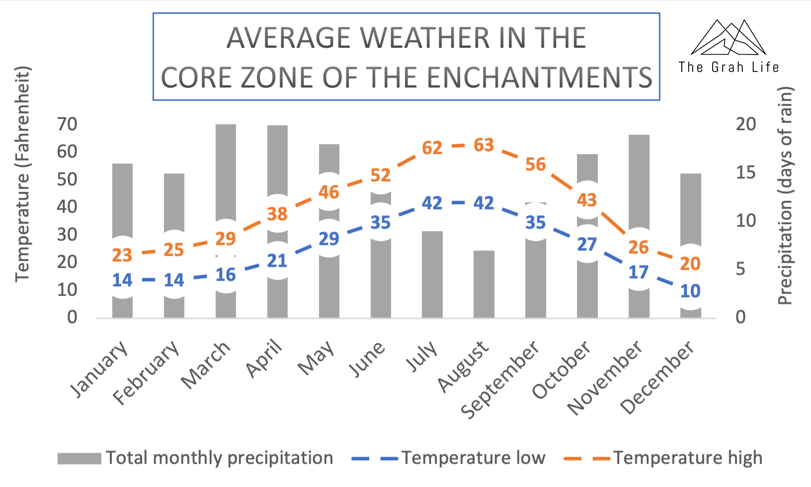
July to August
Zach and I always say summer starts in July in Washington, and this is especially true in the mountains. By July, most snow has melted in the mountains, making hiking trails and roads safe for adventures. These months have the most predictable weather.
You can expect it to be hot and sunny with temperatures in the lower elevations climbing above 100 degrees Fahrenheit. It also gives you the most daylight. Sunrises are as early as 5:45 a.m., with sunsets as late as 9:00 p.m.

Early September
So far, we have always thru-hiked here over Labor Day Weekend. We appreciate the moderate temperatures that still get up to 80 degrees Fahrenheit, a good amount of daylight, and having all summer to train.

View of Dragontail Peak from Aasgard Pass in September
Late September - October
Despite temperatures being in the 60s, with the potential for snow, rain, and shorter days, October is the most popular month to hike here. Why? The larches! Larch trees are beautiful pine trees that turn golden yellow in the fall and drop their needles. They only grow at high elevations and are one of three deciduous conifers that drop their needles for winter.
These yellow trees contrast the scenery so beautifully that hikers flock to the trails with larches — especially the Enchantments. They usually change colors early to mid-October, but it varies each year. Thru-hiking during this time is known as the “Larch March”, and it’s so overrun with visitors that we have never tried to hike here during this time.
Wildfire information
If you’ll be hiking between July and early September, there’s a chance of wildfires throughout the Pacific Northwest. Depending on the fire locations you could deal with trail closures or, more likely, heavy smoke. How much smoke you’re willing to endure is a personal preference, but officials say it’s unhealthy for everyone after the air quality index is above 151.
Current conditions
Look at this site to view air quality throughout Washington and this site to view where the smoke is going. By monitoring air quality in Leavenworth and the surrounding area, as well as smoke and wind patterns, you can predict what conditions you’ll have.
Conditions look poor?
Even if your outcome looks poor, we’d recommend heading to Leavenworth and deciding the day of your hike. The first year we thru-hiked, we arrived in Leavenworth the night before our hike and the skies were blanketed by a thick cloud of brown smoke. We agreed to wake up at 2:00 am as planned and re-evaluate the air quality then. At 2:00 am the skies had completely cleared. We started our hike under the stars and had great air quality the entire day.
It is helpful to keep an eye on wind direction in the week leading up to your hike. This will help you know if it’s likely to change in or out of your favor during your hike as well. Of course, if smoke levels drastically increase on your hike consider turning around. Wildfires can look like large white or grey clouds up close and although it’s unlikely, new ones can always start.

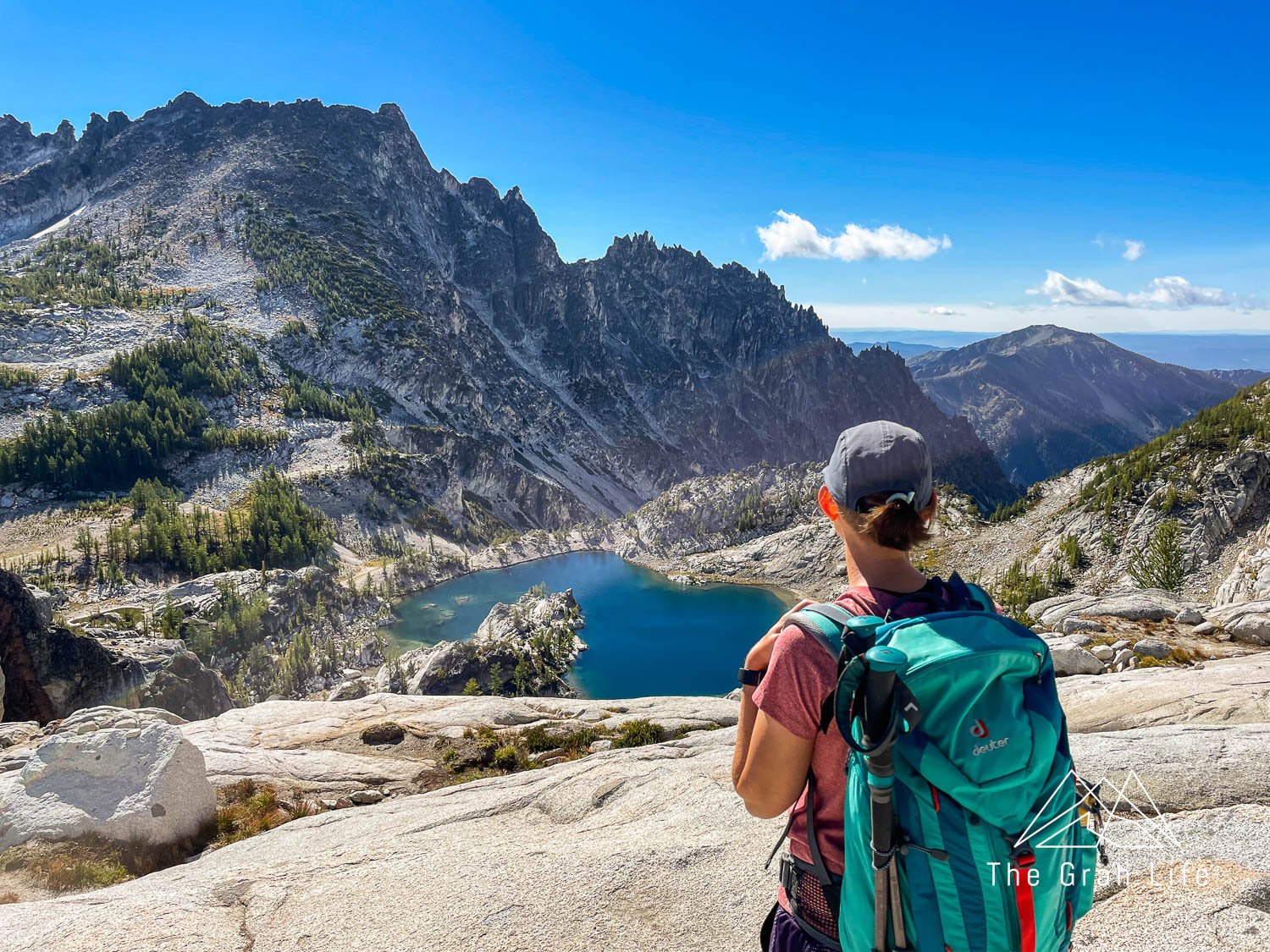
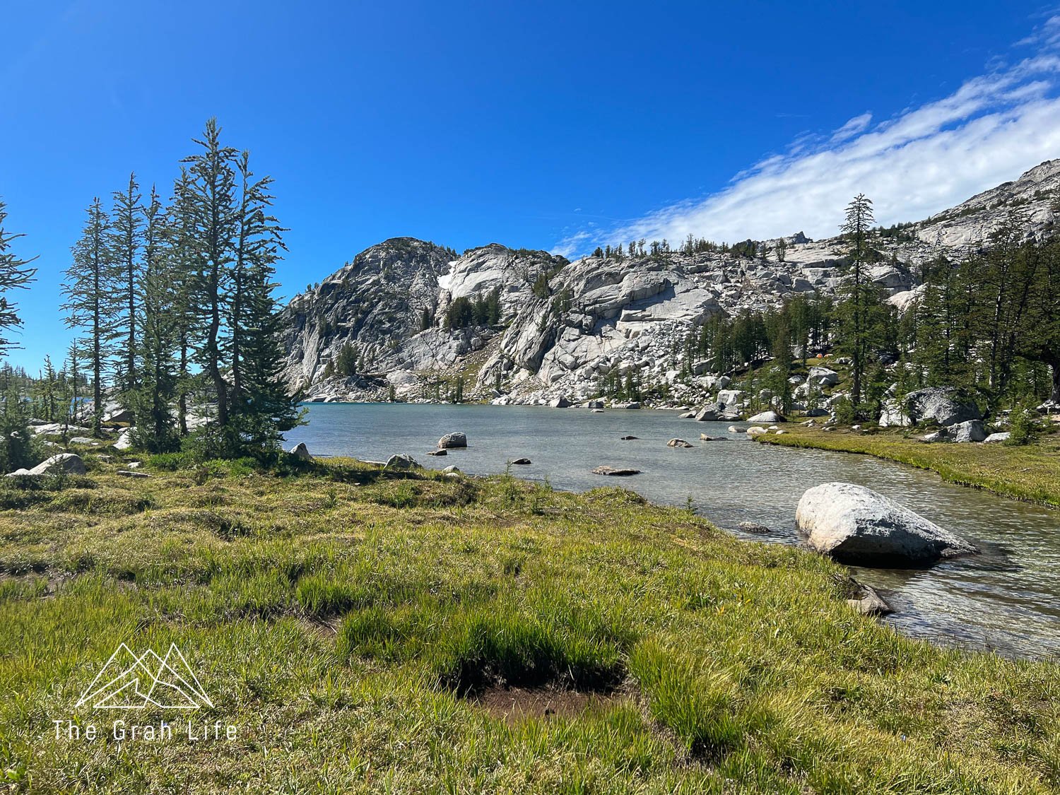
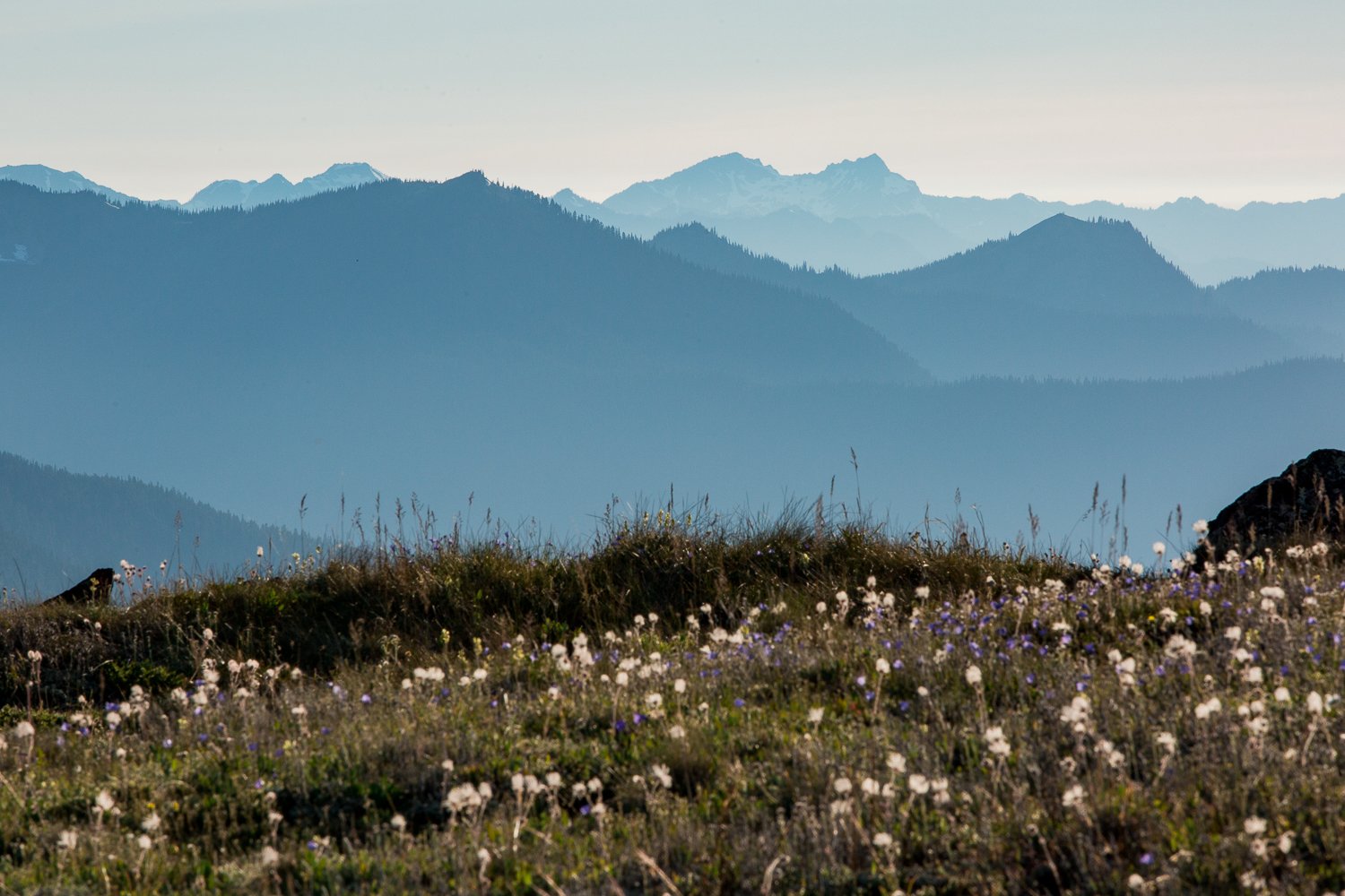
Meadows in the Core Zone
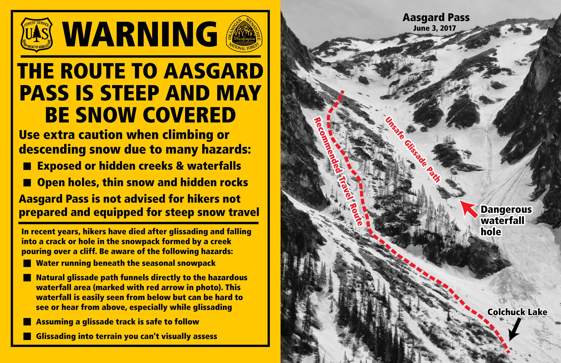
Aasgard Pass
As you can see from the charts above, Aasgard Pass is the steepest section on this hike. Here you’ll ascend nearly 2,000 feet in three-quarters of a mile. This was the part that worried us the most for our first thru-hike. It’s not only steep but there is also no designated path up the pass. You’ll be route finding your way up the mountain through boulders and scree.
If you’re unfamiliar with route finding, do check out the hikes we suggest training on, and be sure to hike a few with route finding required to get a feel for it. Follow what few cairns there are up the pass to the left of the trees midway up the pass. Views of Dragontail from Aasgard are some of our favorites of the entire hike.
We have read trip reports of others getting vertigo on the hike when looking down the pass, but even those in our group that have feared heights and have had bouts of vertigo on trails before didn’t experience this.
We call Aasgard Pass the point of no return. Although we haven’t tried it, we think that descending Aasgard Pass would be more difficult on your body than finishing the thru hike. Don’t go up Aasgard thinking you’ll decide whether to continue on or not at the top. Make that decision before the ascent.

View of Aasgard Pass from Lake Colchuck
Timing
The average length of time it takes to ascend Aasgard Pass is two hours. Find a pace, even if it’s slow, that you can keep up for hours — this will be much easier than starting and stopping repeatedly. Know that once you reach the top, you’re only one-third of the way through your hike. Celebrate making it up Aasgard, but know there is a lot of hiking left!

The start of Aasgard Pass
It’s also advisable to make it up Aasgard Pass before the sun peers over the mountains for a couple of reasons. The first: it’s better to start early than end your hike in the middle of the night. The second: you’ll want to be off the pass when the sun is shining on it. It’s completely exposed, and adding heat to the climb would make it miserable.
From the Colchuck and Stuart Lake Trailhead, you can expect it to take you roughly four to six hours to reach the top of Aasgard. We started our thru-hikes here at 3:30 am, stopping for a snack break right before tackling Aasgard and midway through it. Each time, it took us five hours from the trailhead to the start of Aasgard.
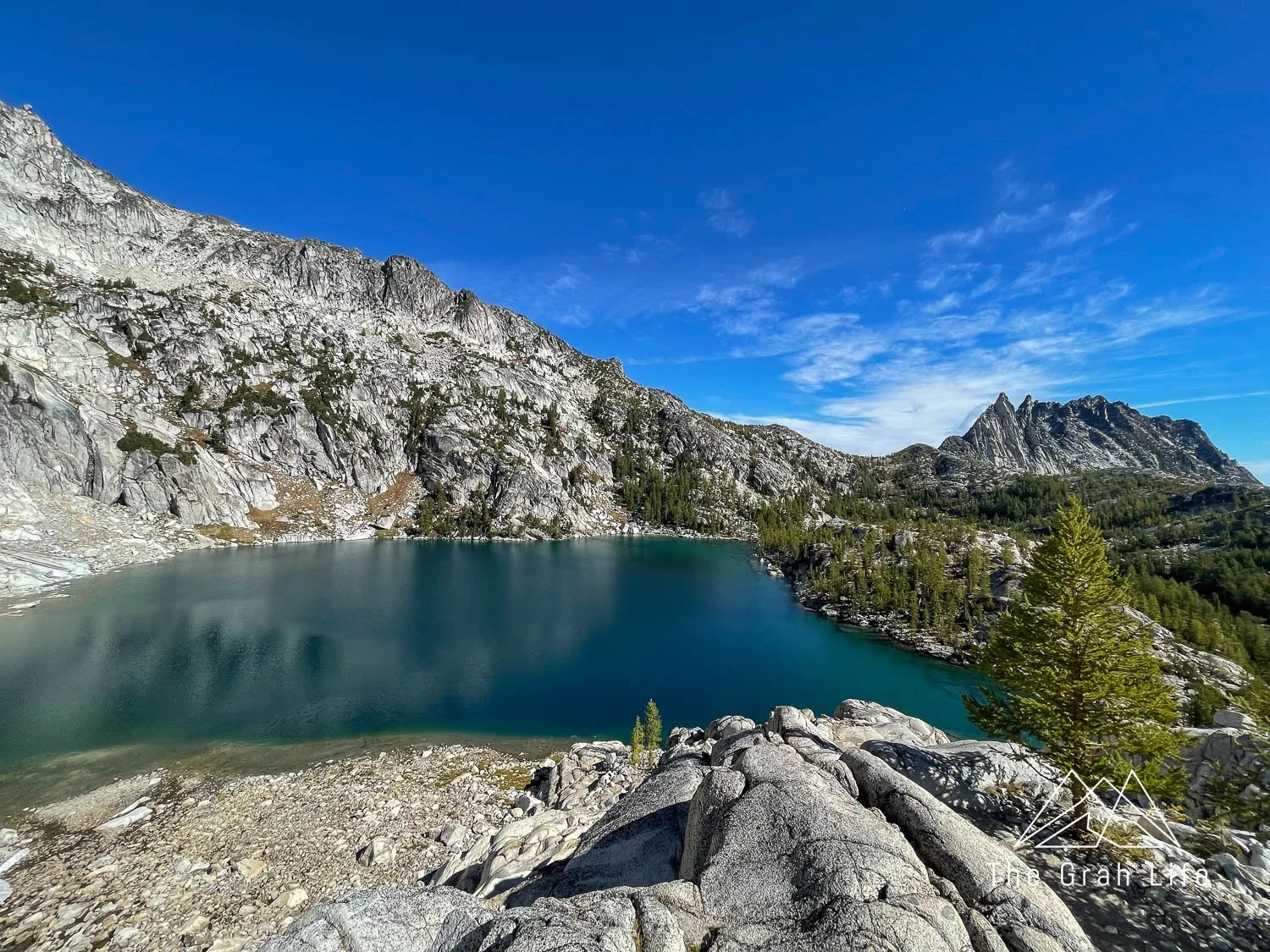
Colchuck Lake
Once you reach Colchuck Lake, head to the left for this iconic view before tackling Aasgard. It’s worth a stop if you haven’t seen it before but we have always skipped it on our thru-hikes since we’ve visited the lake while day hiking.
Head to the right of the lake to get to Aasgard Pass. This is where the route finding begins. Hop across large boulders surrounding the lake until you get to the bottom of Aasgard Pass.

View of Colchuck Lake at sunrise

These photos were taken on the same day — once the sun hits the lake, its green color appears
Early season warnings
If you’ll be thru-hiking early in the season (before July) know that it is not safe and that you’ll need technical mountain climbing skills to ascend Aasgard Pass. The pass is made of large boulders with a river running beneath them. Early in the season, it will still have snow covering the boulders, and it’s possible to fall between boulders, trigger avalanches, or be hit by falling rocks as the sun warms the snow and moves the boulders.
If you’re planning on hiking during this season, please wear a helmet and stay to the left of the trees midway up the pass to avoid this mistake. You should also have avalanche training and check the Northwest Avalanche Center’s mountain weather reports before heading out.
How difficult is the thru-hike?
After 20 miles of hiking, your feet are going to hurt no matter how fast you are, but the slower you are, the more you can expect them (and other body parts) to hurt. After getting through the first 15 miles of the hike, which also happens to be the most scenic, Meghann’s only motivation to move quickly is so she hurts less by the time we are done.
All that to say is that this hike is hard. The first time we thru-hiked it, it was the hardest thing we had ever done. Afterward, Zach said summiting Mount St. Helens twice would have been easier. The following year, we backpacked 20 miles for an elopement we photographed in the North Cascades (camera gear is very heavy!), and that has become the hardest thing we’ve done to date.
Thru-hiking the Enchantments is not a hike to take lightly. The distance, elevation gain, and elevation loss make it very challenging. The terrain is uneven and rocky, and focus is required throughout most of the hike. You’ll need to be watching your steps and be aware of your surroundings the entire hike.

Meghann, just after reaching the top of Aasgard Pass for the first time
How fit do you need to be?
The better shape you’re in, the more enjoyable your experience will be. The first year we thru-hiked the Enchantments, we began training in spring. This consisted of doing a hard hike once a week or going to the gym to climb stairs for twenty minutes and lift weights at least three times a week. We kept this up from April to September.
Check out this list of hikes to start training on.
In general, if you plan on doing this hike, you should be able to walk 10+ miles with a backpack, up and down steep, uneven terrain. Although it’s non-technical hiking (no mountaineering skills are required between July and October), you’ll have to route find from Aasgard Pass all the way through the Core Zone. On top of that, you’ll need to be prepared for weather that can change rapidly in the mountains.

Meghann, looking defeated after seeing how far we have to hike as we left the Core Zone on our first thru-hike

The view of Upper Snowy Lakes after a few miles of elevation loss
Staying hydrated
At a minimum, you’ll drink three liters of water, however, we drank six liters each in 70-degree Fahrenheit weather. If you plan on hiking here during July or August, plan on drinking even more.
Water filters
Bring a water filter (we love our gravity filter) to replenish your water and at least a two-liter container to fill. The smaller your water reservoir, the more often you’ll have to stop and refill but the lighter your pack will be.
We choose to hike with three liters of water in bladders and filter water less often, but most people seem to choose the opposite approach to cut pack weight.

Replace salts
Regardless of when you hike, do bring something to replenish the salt your body will be losing. Salty snacks will likely not be enough to prevent hypernatremia, so take salt pills, like these (caffeinated/non-caffeinated), or Nuun (caffeinated/non-caffeinated).
Last water sources
If you start your hike at the Colchuck and Stuart Lakes Trailhead, Nada Lake will be the last spot you’ll be able to refill water. It’s five and a half miles to the Snow Lake Trailhead from there so be sure you have enough water to finish the hike comfortably. If you hike the opposite direction, Lake Colchuck will be your last main water source at four miles from the Colchuck and Stuart Lakes Trailhead.
Leave No Trace
The Enchantments have a highly-sensitive ecosystem. Following the Leave No Trace Principles are essential to its survival and continued recreation of the area. You’ll need to follow the usual rules of staying on trails and respecting wildlife, as well as a few other things to note.
No dogs allowed
First, keep your dogs (and horses, llamas, and pack animals) at home. They were once allowed but are no longer to help enable the ptarmigan populations.
Toilets
Use the provided toilets along the trail as much as possible. You’ll be able to find signs for toilets near Colchuck Lake, lakes throughout the Core Zone, along the trail near Upper Snow Lake, and Nada Lake.
If you need to pee where there isn’t a toilet nearby, pee on rocks and hard surfaces so the goats don’t disrupt the vegetation to get the salt from it. If you need to poop without a toilet around, you’ll need to use a wag bag and pack it out.
Route finding
Staying on trails while route finding can be tricky but do your best. There are poles and large stacked cairns to lead you throughout the Core Zone, but there will still be times that you may choose paths that don’t work out. If a trail gets very narrow or seems to end, turn around and go back the way you came to find a better route.
Garbage
Just like anywhere else, you should pack out your trash. Keep a Ziploc bag with your food stash — they make for great trash bags and your snack wrappers will be most of your trash.
Do not litter biodegradable items, such as orange peels or apple cores, either. It can take as long as seven years for an orange peel to decompose!
Campfires
Fires are not allowed above 5,000 feet throughout the Enchantments or within ½ mile of any lake, but you can use propane-fueled camp stoves if you’d like a warm meal.
Trail etiquette
Don’t expect solitude on this hike. Be prepared to yield to uphill hikers and pull over to let faster hikers and trail runners pass you.

Wildlife
Mountain goats
You will more than likely see goats on your hike. We’ve seen them throughout the Enchantments, but they are routinely at Colchuck Lake, Aasgard Pass, and in the Core Zone. Wherever you’re at in your hike, you should be wary of them and try to give them lots of space.
Warning: Do not go pee anywhere near them. They are known to charge people while peeing because they want salt. As a result, pee on rocks and hard surfaces to allow the goats to lick the salt from the pee rather than destroy plants trying to get to it. Be especially cautious around baby goats (called kids) because mother goats can be aggressively protective as well.

Bears
Black bears are known to roam throughout the Cascade mountains and the Enchantments are no exception. Do talk and make noise on your hike to prevent from sneaking up on wildlife. We have yet to see a bear in this region but have passed by other hikers who have. Check this article on what to do if you encounter a bear.
Cougars
Of all the animals in the Pacific Northwest, cougars scare us the most. They prefer staying hidden and are quiet and stealthy. Sometimes they escort hikers through their territory but attacks are rare. Again, talk and make noise throughout your hike, especially around blind corners to prevent sneaking up on unsuspecting wildlife, and check here for more information on what to do if you encounter a cougar.
Pikas, marmots, pacific martins
It’s a treat to see each of these animals. You’ll find pacific martins amongst the forest at lower elevations, out in the mornings and evenings. Keep your eyes and ears open for the calls of pikas and marmots at higher elevations. Pikas live in the boulder fields. To spot one, be silent, slow down, or stop before entering a boulder field. Wait a few minutes and you might hear their squeaks or see a tiny mouselike figure standing amongst the rocks. Look for marmots in meadows. They’ll be screaming at one another and gathering grass.
Birds of prey
Each time we’ve day hiked to Colchuck Lake we’ve had the pleasure of watching an eagle catch its breakfast in the lake. Mature eagles have white heads and tail feathers, but adolescents are completely brown. If you see a large bird without the coloring of an eagle, it could be an adolescent bald eagle, a hawk, or an osprey.

The more white plumage eagles have, the older they are
Ptarmigans
The white-tailed ptarmigan is only found in the Cascade Mountains in Washington State and British Columbia. Their plumage changes seasonally and they only live in high elevations. We have seen one in the Core Zone on each thru-hike, and we’ve nicknamed them alpine chickens. They have such fantastic camouflage they nearly blend into the granite rocks.
Climate change is threatening their population, so if you see one you can report details here to help conservation efforts.

Where to stay
Leavenworth is the closest town to the Enchantments. It’s just ten minutes from the Snow Lakes Trailhead and 40 to the Colchuck and Stuart Lake Trailhead. The town itself is adorable. It’s Bavarian-themed, so you’ll find lots of great German food and fun shops.
La Javelina is the best spot for breakfast, and give Yodelin a try for dinner. Do wander the shops as well. Personally, we love visiting the Wood Shop Hat Shop, The Cheesemongers Shop, Posy Handpicked, and the many sweet shops.
Hotels
We love staying at the Bavarian Lodge because it’s at the heart of downtown Leavenworth. You’ll be within walking distance of shops and restaurants and parking is complimentary.
The PostHotel is the most luxurious lodging option in town. It has an ideal location, near shops, and restaurants but it also borders the beautiful Waterfront Park. If you stay here, be sure to treat yourself to their spa treatment post-hike.
Hostel
Check out the Loge Camps if you’re interested in a hostel stay. They have a downtown location with private rooms and shared or private baths and a riverside location with private cabins. Both spaces have lots of communal spaces, so this is a great spot to hang out and make friends.
Campgrounds
The Leavenworth/Pine Village KOA Holiday campground is nearly your only option to camp near town. There are cabins on site, RV, and tent sites, but spots here book up quickly. It’s a well-kept campground.

Insider tips
Start early — before sunrise to maximize your time in cool temperatures, and daylight, and get a parking spot
Don’t start this hike with an empty stomach no matter how early it is
We like to get pizza in Leavenworth the night before and eat the leftovers for breakfast before starting the hike
Eat frequently
You should snack about every hour to two hours on this hike. Doing this instead of larger meals ensures you have a steady supply of calories
Bring a pair of light sandals (Chacos (men’s/women’s), flip-flops, or Crocs work well) with you on the hike
There is a man-made dam across Upper and Lower Snowy Lakes that you’ll need to cross. By fall it’s usually dry but if you’ll be hiking before then, you’ll need to take your boots off to walk across

This is what the dam looks like in late spring.
Bring a change of hiking socks with you on the hike
Once you reach the Core Zone, swim or, at the very least, dip your feet in the water and you’ll feel like a new person with fresh feet and the ability to put on clean socks
If you have a car at the trailhead you’ll be hiking to, stash extra water, Nuun, and snacks in it
Be sure to hydrate well in the days before and after your hike
Do not expect restaurants in Leavenworth to be open late. Even though it’s a tourist town, it’s small, and shops the restaurants stop serving food by 9:00 p.m.
Have a snack planned back at your lodging for dinner if you get off the trail late
Weather changes quickly in the mountains. Bring a raincoat, and sun protection
Check here for the weather forecast
Trail snacks
You’ll want to eat snacks every one to two hours throughout this hike. This gives your body a steady injection of fuel, rather than waiting for larger meals throughout your day. We bring at least ten snacks for each of us, knowing that the hike takes us about 15 hours. Each time we’ve hiked we’ve enjoyed our heartiest snacks right before and after Aasgard Pass.
We love to snack on:
Protein:
Trail mix (gluten-free)
Archer’s Jerky (gluten-free)
Beef sticks (gluten-free)
Hard cheese and salami (gluten-free)
We like to keep these near our water bladder to keep them cool and eat them near the beginning of our hike
Chicken and crackers (gluten-free option here)
Get packets that say “no draining” and you’ll have a much cleaner snack
Bars:
Lara Bars (gluten-free)
Fruit:
Dried fruit, like mango, apricots, or apple chips (gluten-free)
Dried cranberries (gluten-free)
these help with inflammation!
Smoothie pouches (gluten-free)
Chips:
Coconut Crisps (gluten-free)
Terra chips (gluten-free)
Off the Eaten Path veggie crisps (gluten-free)
Parmesan Crisps (gluten-free)
Other:
Energy chews as a substitution for salt pills (gluten-free)

Packing list
Emergency supplies
Don’t forget to add your own personal medications like inhalers or epi-pens.
One headlamp is needed for every member of your group.
Remember to bring backup batteries.
Many hiking first aid kits, like the one listed above, come with blister care but if yours doesn’t, add this to your shopping list. It’s a must-have!
We like this pack of Moleskin because it includes pre-cut pieces which means you’re creating less garbage on the trail and don’t have to fight it with scissors.
We love the peace of mind our Garmin inReach Mini gives us. With it, you’ll have the ability to set waypoints, text others when there is no cell service, and use the S.O.S button for emergencies.
There is a $14.95 monthly subscription fee
Toiletries
This is a game-changer for the women/trans/non-binary folk!! It allows you to go pee standing up. Since you only have to unzip and point the direction you want to let things flow, it’s so much more private than pulling down your pants and squatting.
Use this anywhere to prevent chafing.
Hydration
A LifeStraw isn’t going to cut it here. You’ll need the ability to filter 2+ liters of water at once.
We love using this gravity filter because it’s effortless!
The HydraPak water bladders are the best we’ve tried.
We love that they’re fully reversible — makes cleaning them a breeze!
Salt pills (caffeinated/non-caffeinated)
We use these on the trail, starting at our first snack break, and continue to take one roughly every 45 minutes after.
The caffeinated ones provide a nice, but small, boost of energy.
Nuun (caffeinated/non-caffeinated)
We keep a tube of these in our car and use them after hiking to replenish electrolytes quickly.
They come in tablet form, so there are no messy powders.
If you’re feeling dehydrated the day after your hike, take another.
We use the caffeinated ones to help us stay awake if we have a long drive home after a big hike.

The Platypus Gravity Filter
Food
1-2 snacks for every two hours you expect to be hiking
Check out what we snack on in the list above.
Gallon Ziplocs for your garbage
Clothing
Sandals to cross the dam at Snow Lakes (men’s/women’s)
Any lightweight, waterproof sandal or Crocs will do.
Neutrogena Ultra Sheer SPF 70 Sunscreen
This sunscreen has the safest product rating for sunscreen on the EWG’s Skin Deep guide.
Dry your feet off well to prevent blisters
You’ll need this for the water crossing and whenever you choose to dip in a lake.
Warm hat, gloves, and more layers if you’ll be hiking in the fall
Hiking gear
We love these Deuter daypacks because they come with built-in rain covers.
Zach attracts mosquitos like you’ve never seen and this spray works just as well as 90% deet.
The mosquitoes are worst in July and August.
Parking passes
You’ll need one of these passes (not both) for each car you’ll be leaving at a trailhead. Purchase them online ahead of time, or in Leavenworth at Der Sportsman.
Northwest Forest Pass ($5 for a day pass or $30 for the year)
America the Beautiful Pass ($80 for the year, covering some National Park entrance fees)


Search the blog for more adventures! Try searching for topics such as “hiking”, “waterfalls”, or “Washington”.