2-5 Day Moab Itinerary (Overlanding, Hikes, and More)
Located in southeastern Utah on the Colorado Plateau, Moab is a small town known for its outdoor activities. While it’s home to Arches and Canyonlands National Parks, off-roading, rafting, biking, and climbing are just a few popular activities in the surrounding area.
At a minimum, we recommend staying for two days to explore both national parks, although it’s worth spending more time if you can.
Know what you’re searching for? Click on a link below to skip to a section.
Park details
Moab is home to one state park, two national parks, beautiful national forests, and BLM land. You’ll find roadside petroglyphs, incredible views, and enough recreational activities to keep you busy year-round.
Arches National Park
Arches is known for having over 2,000 natural stone arches, pinnacles, and fins, all in a beautiful red color. Sunsets are particularly stunning here, and the entrance to the park is just ten minutes outside of town.
Canyonlands National Park
Canyonlands is famous for its overlanding and mountain biking routes. The park has large natural stone arches, sandstone spires, canyons, and dark skies. Located 40 minutes outside of Moab – choose to arrive by overlanding the famous Shafer Trail or highway.
Dead Horse State Park
Located between Canyonlands and Moab, Dead Horse State Park is a must-visit location. The views into the canyons and rivers below rival the national parks, and it’s also a dark sky sanctuary.
Manti-La Sal National Forest
Just 20 miles south of Moab, the La Sal Mountains are known for having cooler temperatures with lots of climbing, overlanding, and camping available.
When to visit
Best weather
March to May
Spring is the best time to visit Moab because temperatures are milder, with little precipitation. The days are still warm, but not extreme like the summer months. The warm and dry weather is best for the area’s most popular activities, like hiking, rafting, and climbing.
Best fall colors
September to October
We visited in October and loved the warm days and cooler nights. Visit by early to mid-October to have more daylight. However, between July and September is monsoon season. If you visit in September, be aware of flash floods, especially when hiking, overlanding, and climbing.
Best prices
November to February
Although you can expect some businesses to close for the season, many activities are still available throughout winter. This is also the quietest time to visit, and with that comes great discounts on lodging.

Getting to Moab
The Canyonlands Field Airport (CNY) is the closest international airport to Moab, just 18 miles north of Moab. It’s smaller, so you’ll be more likely to find direct flights to Utah’s larger airport in Salt Lake City (SLC), which is a four-hour drive from Moab.
Either way, you’ll need a car to explore the area. If you’re not interested in overlanding (driving the Shafer Trail, or more), then any rental car will work. If overlanding is a must, rent from Twisted Jeeps. All their Jeeps are well-prepared for off-roading, with aired-down tires, lift kits, and trail armor.
Park Passes
Canyonlands National Park, Arches National Park, and Dead Horse State Park all require parking passes. For Canyonlands and Arches, you can purchase a seven-day pass for $30 for each park, or an America the Beautiful Pass for $80. The America the Beautiful Pass covers all national parks for one year from the purchase date, so this is the best purchase if you plan on visiting other national heritage sites or national parks.
To visit Arches National Park, you’ll also need to purchase a timed entry reservation or enter the park before 7 a.m. or after 4 p.m. between April and October.
Dead Horse State Park has a daily pass for $20 entrance fee that includes up to eight people. Annual permits are available for $125. Purchases can be made in person, online, or via the Utah DNR State Parks app.
Where to stay
Although Moab is a small town, it has great campgrounds and lodging accommodations. We’ve got another blog with the best campsites listed here, and the best lodging options for every budget listed here.
Is Moab pet-friendly?
Moab is somewhat pet-friendly. Pets are allowed at Dead Horse State Park, in the La Sal National Forest, and on some BLM land. Check out this list to find pet-friendly hikes near Moab.
Arches and Canyonland National Parks are not pet-friendly. In Canyonland, pets are not allowed on trails, overlooks, or in the backcountry (including in vehicles). Arches allows leashed pets in parking areas, campgrounds, and picnic areas only.
Service animals are an exception to these rules.
Pet heat warnings
While in Moab, do not leave pets unattended in vehicles – cars heat up quickly, even with the windows cracked. Keep your pets' paws from burning by testing the pavement first. If it’s too hot to hold your hand on the pavement for 7-10 seconds, it is too hot for dog’s paws.
Best hikes
Moab and the surrounding parks are full of great hikes. You’ll find hiking suggestions in the itinerary below and a list of the best hikes near Moab here.
Please carry and drink at least two liters of water while hiking in Moab. Start hikes early in the day – most hikes are very exposed!
Best activities
Off-roading and overlanding
Moab is known for off-roading and overlanding. With trails like Metal Masher, Chicken Corners, and Onion Creek, there is something for everyone’s experience and comfort levels.
If you’re interested in exploring this way, rent a vehicle from Twisted Jeeps. All their Jeeps are prepared for off-roading, with aired down tires, lift kits, and trail armor. They also offer tours where you can ride with them, follow while driving one of their Jeeps or follow in your own 4x4.

Climbing and canyoneering
Moab is a top destination for rock climbers because it has a variety of climbing routes, landscapes, sandstone cliffs, towers, and arches. There are adventures and tours for every skill level.
If you’ll be climbing on your own, check this list of springtime trail closures on BLM land to protect nesting raptors. If it’s rained, wait at least 36 hours to climb. Climbing on wet sandstone can break and damage holds. and please only use red chalk. White chalk is prohibited.
Mountain biking
Moab is full of awesome biking trails. The Slickrock trail is the most famous, but you can check out an interactive map of trails here. Guided tours of all kinds are available from Rim Tours, and you can arrange a shuttle and bike rentals from Moab Cyclery.
Do not mountain bike after it rains. Biking on wet trails can create grooves in the trail.
Stargazing
Canyonlands, Arches, and Dead Horse State Park are all dark sky parks. Time your trip with a new moon for the best stargazing. All three parks have ranger-led activities in the evenings varying from talks to scorpion hdeunts! Check the calendar for Canyonlands here, Arches here, and Dead Horse here.
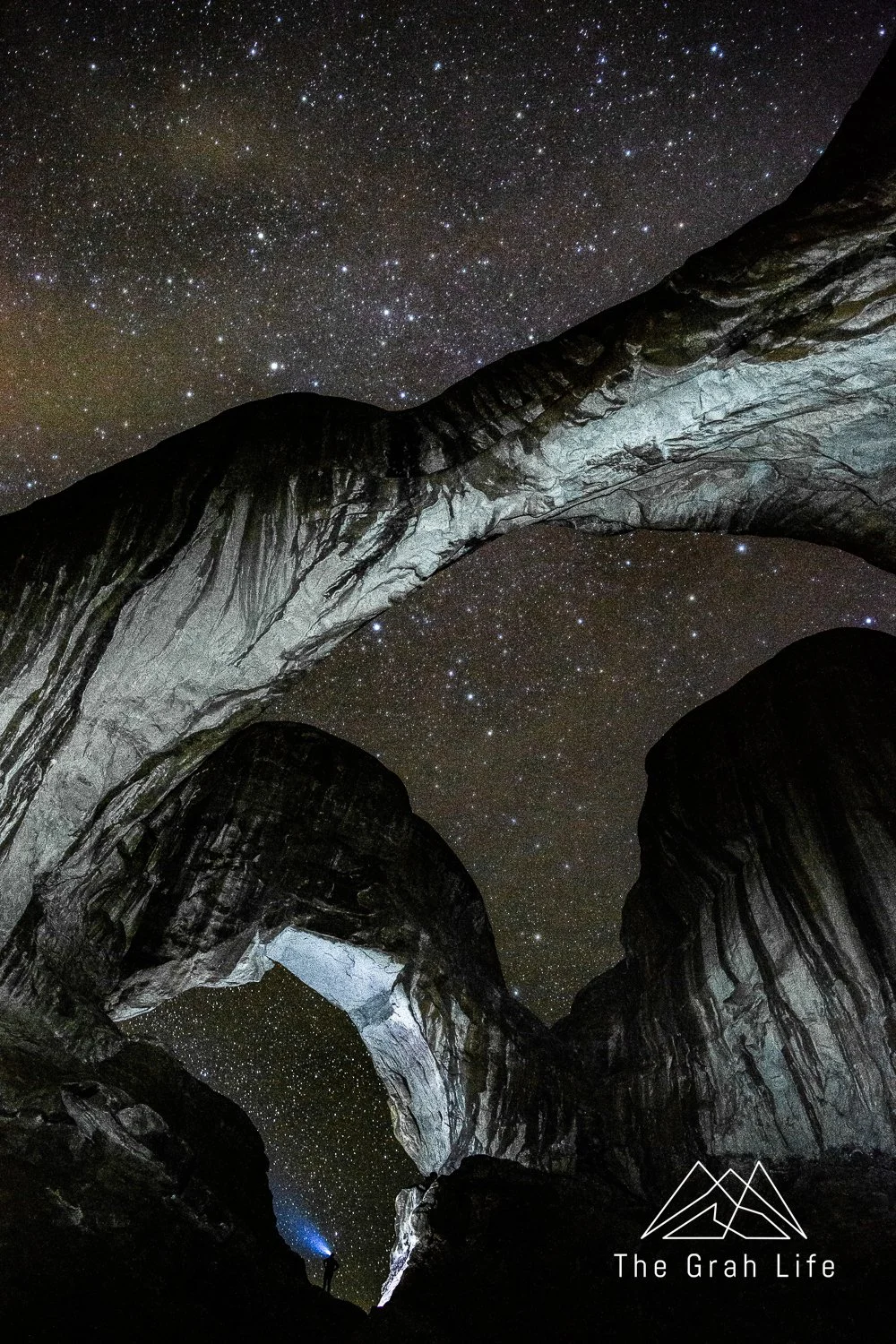
Double Arch
Air travel
Take a helicopter or airplane tour over Canyonlands, Dead Horse State Park, or the backcountry of Arches National Park with Redtail Air. Tours range from more affordable 20-minute rides up to three hours.
Water activities
Whitewater rafting
Raft the Colorado River with World Wide River Expeditions! They have half-day, full-day, and multi-day trips. Choose between quiet floats, introductions to whitewater, raging rapids, or a bit of everything.
Paddling
Paddle on lakes in the La Sal Mountains (check out day four of the itinerary below for suggestions) or on the Colorado River. Check out Wild West Voyages for kayak and paddle board rentals, tours, and shuttles, or the Canyonlands by Night & Day for tube rentals and a shuttle up the Colorado River.
Cruises
Canyonlands by Night & Day also offers a variety of boat tours. Choose between adventurous jet boat rides, sunset rides with live music, or our favorite tour, a night ride where they light up the cliffs and share the history of Moab.
Moab itinerary
This itinerary is built so that you can do it in any order, although days one and two offer the best overviews of the national and state parks in the area. Some days will be longer, more tiring, or involve more time in the car, so we’ve balanced them with days of various activities between.
We recommend spending at least two days in Moab, and although our itinerary goes up to five days, it would be easy to add another day or more with the addition of a guided tour or activity.
If you’re arriving in town in time for one activity in the evening, head up to Dead Horse State Park to stargaze if it’s clear out or to Arches National Park for a sunset hike. Hike to Delicate Arch if you have more time, or The Windows for a quick walk. More on each in the day one itinerary.
Itinerary breakdown
Day 1: Overview of Arches National Park
Day 2: Overlanding to Canyonlands National Park
Day 3: Hike Devil’s Garden in Arches National Park
Day 4: Overland the La Sal Mountain Loop and/or paddleboard
Day 5: White Rim Road in Canyonlands
Day 1: Overview of Arches National Park
Mileage: 54 miles
Drive time: 1 hour and 45 minutes
Arches National Park has timed entry reservations between 7 a.m. and 4 p.m. Just like when visiting Mount Rainier, we advise going into the park before 7 a.m. This ensures you see all the major sights without the crowds and have easy access to parking. This day is all about seeing as much of the park as possible!
Overlooks
As you make your way into the park, stop at all the pullouts to enjoy the views. We especially loved the La Sal Mountain Viewpoint around sunrise and sunset. Stop at the Courthouse Towers Viewpoint for a great view of the Three Gossips, Sheep Rock, the Tower of Babel, and the Courthouse Towers.

La Sal Mountain Overlook
Shorter hikes
After Balanced Rock, take the Window’s Road to Double Arch. It’s a quick 0.6-mile hike to reach the infamous arches.
If it’s not too hot, check out the Windows Loop Trail across the parking area next. This is a 1.2-mile loop featuring Turret Arch and the North and South Windows.

Prioritize getting permits for this 2.1-mile hike and scramble. You’ll hike through sand fins and view multiple arches; however it’s easy to get lost. Carry a map or go on a ranger-led tour between March and October (GPS devices will not work). The tours and permits book up months in advance, so it’s best to make reservations as soon as they go on sale. Do this hike first if the forecast is hot.
Sand Dune Arch
Next, stop at the Sand Dune Arch Trailhead. It’s a 0.3-mile hike through a slot canyon to reach the Sand Dune Arch under a beach of sand.
Delicate Arch is Arches National Park’s most well-known hike. It’s best at sunset, but going at sunrise is a more peaceful experience. The parking lot is small, so arrive with time and patience to spare. The hike is 1.5 miles each way with about 500 feet of elevation gain.
You’ll find Wolfe Ranch at the start of the trail. Stop here for a glimpse of what a homesteader’s life was like around 1906.
If you have time, take the first trail to the left after your cross the bridge next. It’s not the most direct route to Delicate Arch, and it will add about 10 minutes to your hike, but you’ll get to see the Ute Indian Petroglyphs on your way. Finish the loop to get back to the main trail heading to Delicate Arch from there.
Day 2: Overlanding to Canyonlands National Park
Mileage: 123 miles
Drive time: 5 hours
Overlanding into Canyonlands via the Shafer Road is one of the most memorable parts of our trip to Moab.
We have two routes you can take – the traditional route, or a more advanced off-roading route that we loved. This blog has route details, as well as all the must see stops along the trail.

Canyonlands National Park
Exit the Shafer Trail into Canyonlands National Park. Here you’re going to stop at all the main viewpoints and have the option to go on a few short hikes.
Shafer Canyon Overlook
This is the best spot to view the Shafer Trail switchbacks from above. This and the Shafer Trail Viewpoint is where all the iconic images looking down into the Shafer Trail are taken.

Mesa Arch
Mesa Arch is one of Utah’s most famous arches. It’s 27 feet long and frames the rock spires and La Sal Mountains in the distance. It’s on a 0.7-mile relatively flat hiking loop and takes about twenty minutes to walk there and back.
Green River Overlook
Take a side road to reach the Green River Overlook next. The overlook is a quick walk from the parking area and has some of the best views into the canyons in the park.
Buck Canyon Overlook
Stop in this loop to walk to take a two-minute walk out to the Buck Canyon Overlook. You’ll have a great view of the White Rim Road from here.

White Rim Overlook
This spot has shaded picnic benches – it's the perfect lunch stop. While you’re here, you can hike the 1.8-mile trail to the White Rim Overlook or keep driving for more views ahead.
Orange Cliffs Overlook
Take a quick stop here for views into the valley below, right off the parking lot.
Grand View Point
Many say the Grand View Point Trail is the best hike in the Canyonlands. It’s 1.8 miles roundtrip, but if you’re not feeling up to that, there is an overlook just 100 feet off the parking lot.
Dead Horse State Park
You’ll be passing by Dead Horse State Park on your way back to Moab just in time for sunset. It cost $20 per vehicle, but this will be one of the most beautiful sunsets of your life.

Overlooks
If you have time before the sun goes down, hike 0.1 miles to the Basin Overlook or 0.5 to the Meander Overlook before heading to the end of the road.

Dead Horse Point
At the end of the road is Dead Horse Point. Explore the West Rim Trail, overlooking the Gooseneck Overlook on the Colorado River where you started your day. The sunset is especially beautiful here, casting a golden glow across the valley’s red rocks.

Dark Sky Sanctuary
If this day isn’t already long enough for you, Dead Horse State Park is also a dark sky park. Skies darken two hours after sunset, so you can choose to wait it out, or come back to visit another night. If you do stay – you're in for a treat. With Dead Horse State Park’s location on a high plateau and away from cities and mountains, you’ll have a full view of the sky.
Check the program schedule for talks with rangers about bats, geology, stars, and black light scorpion hunts!

Astrophotography photo taken in Arches National Park — Dead Horse State Park would have even darker skies and less light pollution (the yellow color in the photograph)
Day 3: Hike Devil’s Garden in Arches National Park
Mileage: 40 miles
Drive time: 80 minutes
Although Delicate Arch is the most well-known arch in Arches National Park, Devil’s Garden is the best hike. It’s full of arches, spires, and narrow rock walls called fins. The area is exposed, with scrambles and climbs. Bring at least two liters of water per person, snacks, and sun protection (find more on what we pack hiking here).
The Devil’s Garden trail is a lollipop loop with optional side trails. Hike the entire eight-mile loop, and spur trails, to see seven arches.
For a shorter hike, consider turning around at the Landscape Arch (two miles roundtrip), or Double O Arch for a four-mile hike. Adding the Navajo and Partition Arch Trails onto the route to Double O Arch adds 0.8 miles, while taking side trails to Pine Tree and Tunnel arches add 0.5 miles to either hike.
Food Truck Park
Head back into town for a great post-hike meal. This food truck court boasts of 14 trucks and plenty of shaded seating.
Shopping in town
While you’re in town, walk down the main street to grab souvenirs. We loved visiting Moab Made and tumbleweed.
Day 4: Overland the La Sal Mountain Loop and/or paddleboard
Mileage: 105 miles
Drive time: 3.5 hours
La Sal Mountain Loop
The La Sal Mountain loop is a great spot to explore outside Moab and the National Parks. You’ll get to see dinosaur tracks, petroglyphs, lakes, and great rock formations. Plus, it’s known for having cooler temperatures than the surrounding area.
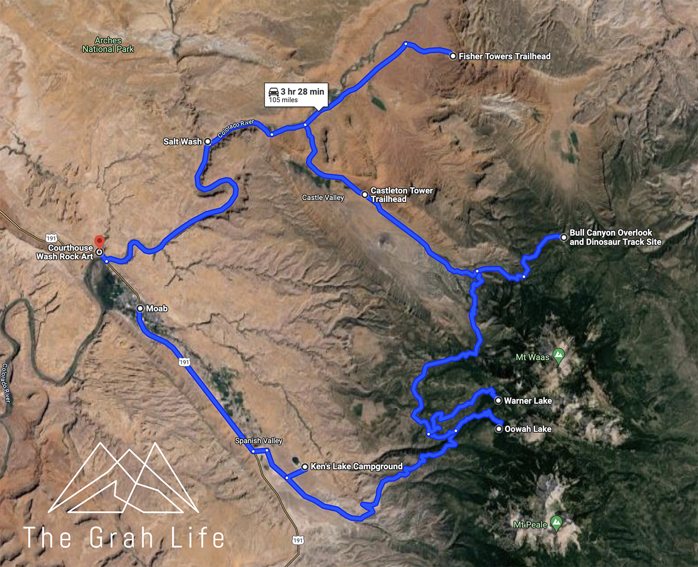
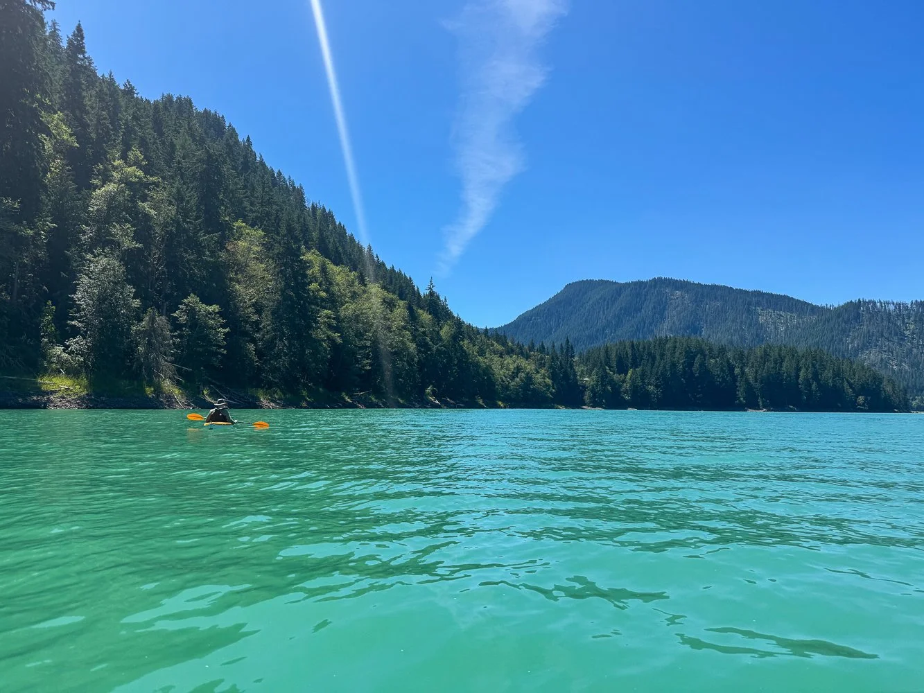
Rent paddle boards from the Wild West Voyages to get on the water on one of the first three stops on the route. Ask about water levels before going – they were low when we visited in the fall.
Along the way, stop at Ken’s Lake, Oowah Lake, and Warner Lake. From there drive to the Bull Canyon Overlook. The offshoot to reach the Bull Canyon Overlook adds twenty minutes of driving in each direction, but we think it’s worth it!
Your next point of interest is Castleton Tower. The rock spires are visible from the trailhead, but it’s possible to hike and scramble closer. It’s very exposed, so plan accordingly if you’re interested in hiking.
Fisher Towers is next. Again, it’s 15 minutes out of the way, but worth the detour. The views are impressive from the trailhead, and if you’re interested in hiking, it’s a 4.2-mile trail with some scrambling and route finding. Since it’s all exposed, it’s best to hike here in moderate temperatures or early in the morning.
If you’d like to extend your drive, consider going out and back on the Onion Creek Trail. To complete the scenic portion of the road, it adds a half hour each direction.
Your last stop is at the Courthouse Wash Panel. This is a wall of rock paintings. Although it cannot be dated, it’s thought to be created by Archaic Indians. Please help preserve the markings by not touching them.

Onion Creek
Day 5: White Rim Road in Canyonlands
Mileage: 125 - 150 miles
Drive time: 6 – 14 hours
This suggestion is for those who love overlanding, mountain biking, and dispersed camping! Although it’s possible to drive the White Rim Road loop in one long day, it’s popular to camp or drive as a shorter out and back route.
If you’re not up for this, a great alternative would be exploring the Needles District of Canyonlands via a hike.
Permits
If you choose to mountain bike or drive the White Rim Road, you’ll need to purchase a permit for every vehicle in your group. There are 50 permits issued per day. 25 permits are available for purchase 24 hours in advance, and 25 are available to purchase at the visitor center the day of.
Camping
If you choose to camp, you’ll need to purchase an overnight permit for each campground you plan on staying in. These are available for purchase up to four months in advance and are highly competitive in the summer months.
Please pack out everything you carry in, including human waste!
Shorter out and back routes
Both shorter routes include about six hours of driving. If you do not have experience off-roading, explore this area with a tour.
Shafer Trail to Monument Basin
The eastern side of the loop is more populated and scenic. For this route, you’ll drive from the Canyonlands Visitor Center, down the Shafer switchbacks, stopping by scenic points like Musselman Arch, Lathrop Canyon, and the Airport Tower Viewpoint. Turn around at Monument Basin Overlook.
Mineral Bottom Road
This route is more technical and challenging than the eastern route, and therefore more remote. Here you’ll get to drive the Mineral Bottom Road switchbacks, drive along the Green River, and check out Holeman Canyon Viewpoint. Turn back at the start of Murphy’s Hogback.
White Rim Road loop
If you’re up for a 12+ hour day, it’s possible to drive the whole loop. This will be a long journey with a speed limit of 15 miles per hour and rough terrain. Only attempt this between mid-April through mid-August when there is plenty of daylight.
It’s advisable to go clockwise, starting with the Shafer Canyon switchbacks. The final 13 miles on the Mineral Bottom Road are easy to handle even if it’s getting dark. Even so, start this drive at sunrise and skip the lengthy detours to Lathrop Canyon and White Crack. Turn around if you haven’t reached the White Crack Road (the halfway point) by 2 pm.
Leave no trace
Please practice Leave No Trace Principles in your travels to Moab. Of these principles, it’s so important to stay on designated trails – stepping off the trail hurts the biological soil in the Colorado Plateau’s high desert.
Do not climb, scramble, walk, stand, or rappel off any arch with an opening greater than three feet.
There are also petroglyphs and picture rocks located throughout the region. Do not scratch, alter, or touch them, and please leave what you find.

The “birthing scene” prior to vandalism in 2021
Park tips
Gas stations
There aren’t any gas stations in the parks or national forests. Leave for a day of adventure with a full tank.
Cell service
There is limited cell reception surrounding Moab, especially when hiking or overlanding near canyons and fins. Download all maps ahead of time and be prepared for emergencies.
Heat
Even in the spring and fall, temperatures can get very hot. Start your hikes early and bring plenty of water, snacks, and electrolytes.
Food
None of the parks offer food. Be prepared and bring plenty of water and snacks.

Where to go next
Salt Lake City
Located four hours north of Moab, Salt Lake City is a great place to fly into. While you’re there, visit the Bonneville Salt Flats, climb in the Cottonwood Canyons, hike in the Wasatch Mountains, or ski at one of their 10 resorts.
Lake Powell
Page, AZ is four and a half hours south of Moab. Here you can tour slot canyons, explore Lake Powell, and check out the infamous Horseshoe Bend at sunset.
Telluride, CO
Drive three hours east to reach Telluride. Here you’ll have more hiking, boating, off-roading, and climbing in the San Juan Mountains.
Utah’s mighty five
You’ll find Capitol Reef National Park, Bryce Canyon National Park and Zion National Park a two-, four- and six-hour drive from Moab, respectively. Start or end your trip in Moab to visit all five parks.


Search the blog for more adventures! Try searching for topics such as “backpacking”, “waterfalls”, or “Oregon”.