Enchanted Valley Backpacking
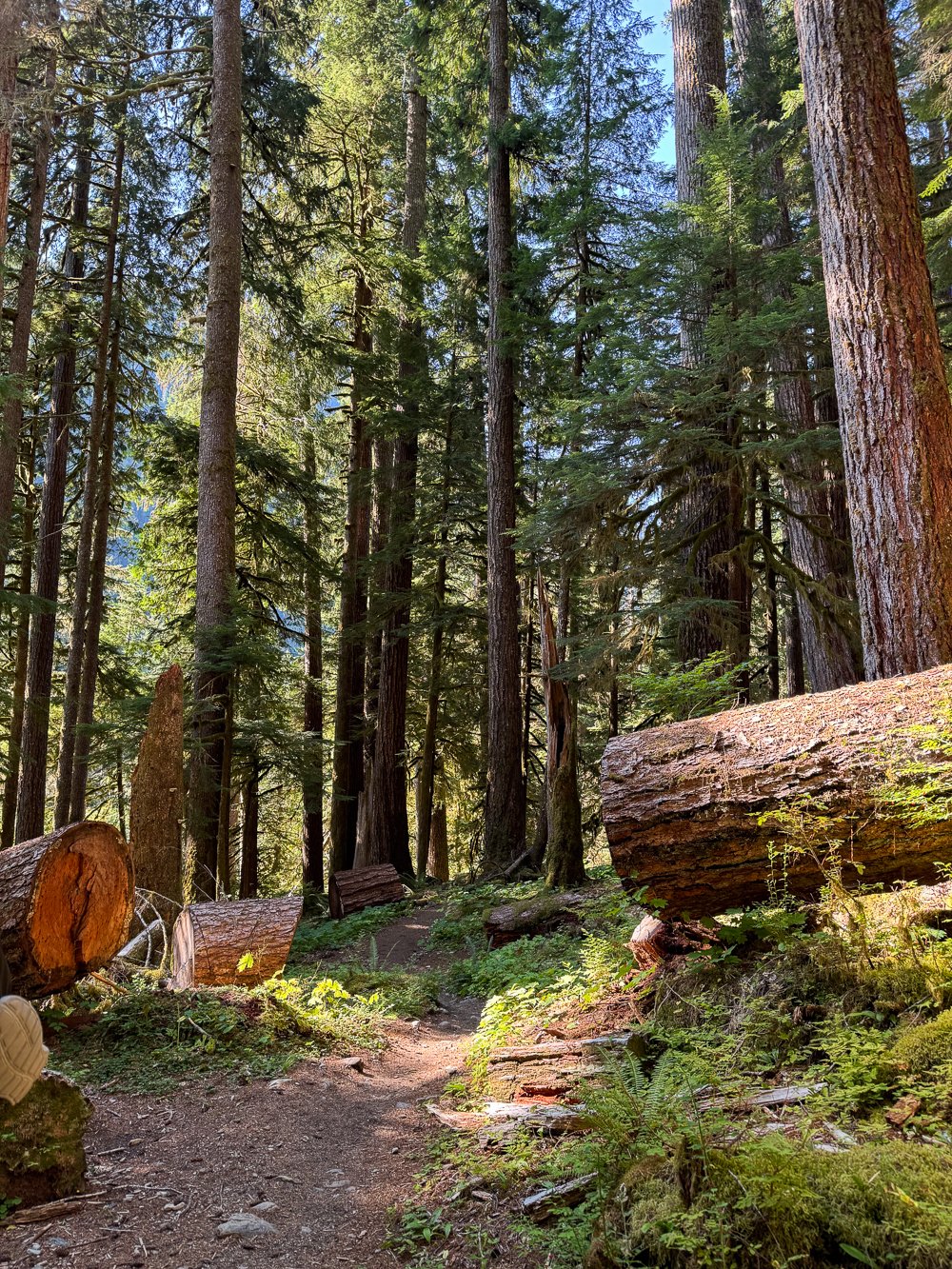
Known as the “Valley of 10,000 waterfalls”, Enchanted Valley is a beautiful backpacking destination in the Olympic National Park featuring the Enchanted Valley Chalet. The trail follows the bright blue Quinault River through old-growth forests and features trees up to 1,000 years old. The forest is so impressive it reminded us of Redwood National Park.

Trail overview
Park at Graves Creek Trailhead, just down the road from Graves Creek Campground. You’ll find space for about twenty cars and a vault toilet here.
The trail is immediately beautiful, with great views of the Quinault River. The farther you hike into the trail, the larger the trees get.
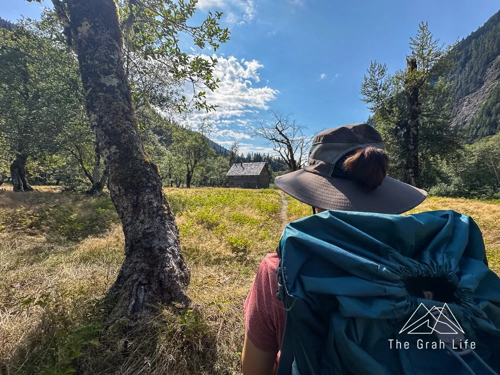
Located 13.5 miles into the trail, the Enchanted Valley Chalet is the most popular destination on this trail. Another big draw is the wildlife here. There are frequent black bear sightings, especially in the spring and early summer.
Trail description: Washington Trails/Alltrails
Distance: 27.8 miles
Elevation gain: 3,700 feet
Dogs allowed on a leash: No
Permits: Required from recreation.gov under the Olympic National Park Wilderness Permit’s section on Quinault
Water source: All campgrounds are located along the Quinault River and have easy access to water.

The Quinault River in late August
Campfire information: Campfires are allowed below 3,500 feet at Pony Bridge, O’Neil Creek, Pyrites Creek, and Enchanted Valley if there is no burn ban in place.
Toilets: Pony Bridge, O’Neil Creek, and Enchanted Valley campgrounds have pit toilets available. There are also a few campsites between each campground. At these sporadic campsites, as well as Pyrites Creek Campground, you’ll need to bury waste 6-8' deep and 200 feet from water sources and campsites. Please pack out toilet paper.
Bear canisters: Bear vaults are required at Pony Bridge, Enchanted Valley, and beyond. Food hang bags are allowed at O’Neil Creek and Pyrites Creek Campgrounds. Both campgrounds have bear wire, but bring paracord just in case lines are broken. You’ll find product recommendations for each item listed here.

Best season
March to November
We love this trail because it’s one of Washington’s few backpacking trails that is accessible in the early spring. From spring into early summer, you’ll find countless waterfalls in the valley, lush vegetation, a couple of river crossings, and a very muddy trail.
Summer brings wild huckleberries, and by fall the trail and waterfalls are dry. Instead, you’ll find a calmer river with spots to wade as you search for quartzite in the riverbed.
By late fall, the trail becomes muddy again as the winter rains bring back the waterfalls into the valley.


Wild blueberries
How long should your trip be?
We backpacked here over three days, taking one day for the hike in and out and one day to day hike to the Enchanted Valley Chalet. From O’Neil Creek, the Chalet is just over a 14-mile roundtrip hike. From Pyrites Creek, it’s a more manageable nine-mile roundtrip hike.

For a more relaxing pace, purchase permits for whatever campground you feel inclined to stay at, moving your campsite each day. The most popular itinerary includes one night at Pyrites Creek, one night at Enchanted Valley, followed by a night at Pyrites Creek or O’Neil Creek before hiking out.
Remember, you’ll need consecutive permits for each campground you plan on staying in.
Is this trail beginner backpacking-friendly?
Yes. With rolling hills and an easy incline, this trial is great for beginner backpackers. If this is your first time backpacking, we’d suggest getting permits to stay at Pony Bridge for one night before moving on to O’Neil Creek (by permit) if you feel inclined. You’ll find a list of other great beginner backpacking trips in Washington, here.

What campgrounds should you get permits for?
Pony Bridge
Pony Bridge is located 2.5 miles into the hike. We saw three smaller campsites located right off the trail, just past the bridge. There were two more sites located roughly one and one a half mile down the trail that had river access.

O'Neil Creek
After perusing sites at Pyrites Creek on our way to Enchanted Valley, we determined that O’Neil Creek has the best campsites! You’ll find the turn-off to reach O’Neil Creek 6.7 miles into the trail. From there, you’ll walk down a 0.25-mile spur trail. The extra effort pays off as these campsites have extra privacy and access to bear wire.
There are five campsites here, including two larger group sites. All but one site has river access.

The trail and campgrounds are very well marked

Passing time playing cribbage
Pyrites Creek
Campsites at Pyrites Creek are located on both sides of the river 9.5 miles into the hike. There are twelve campsites here. You’ll come across the largest campsites first, with smaller sites located across the river. Bear wire is located here as well.

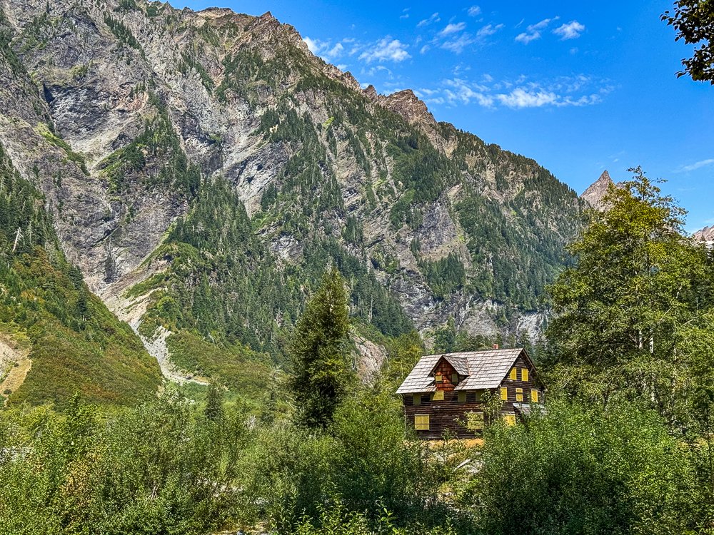
Enchanted Valley
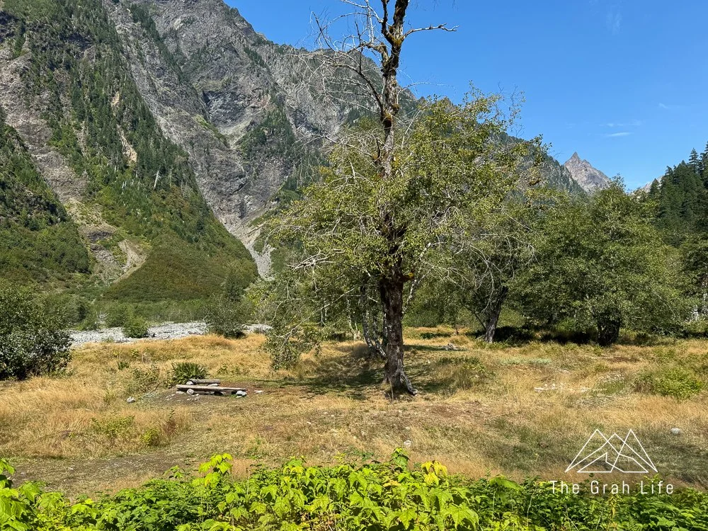
Enchanted Valley is located 13.5 miles into the trail. Here the river is wide, and unlike the other campgrounds, the area is more meadow than forest. Campsites are spread out throughout the valley with great views of Anderson Pass.
Campsite near the Enchanted Valley Chalet
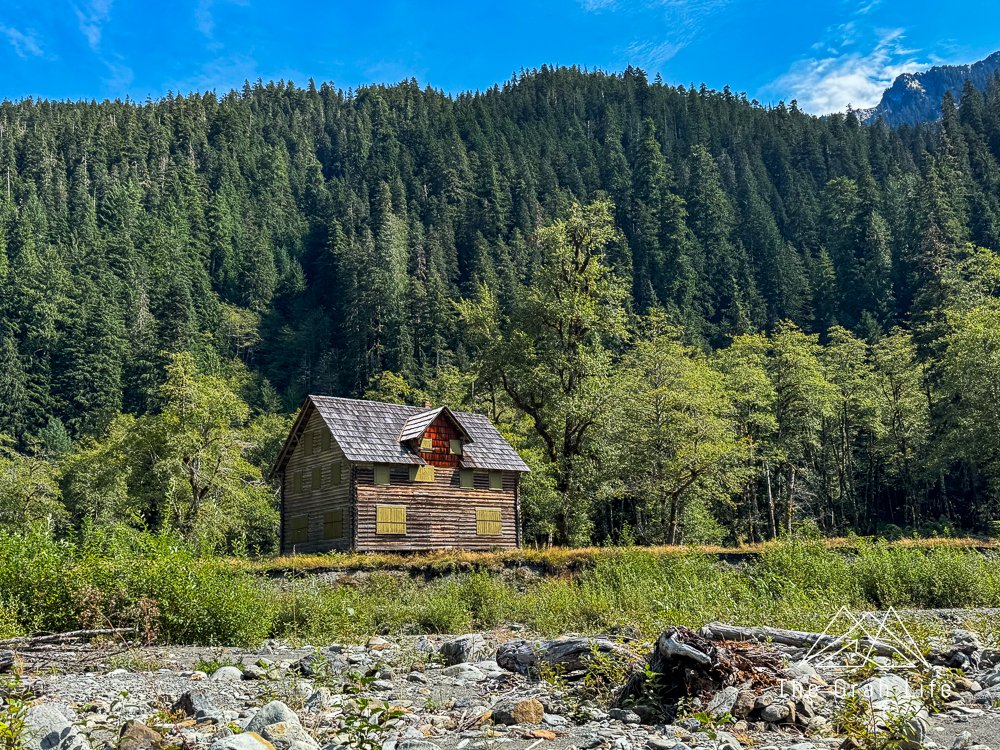
Enchanted Valley Chalet History
In the 1920’s the Olson Brothers, who incorporated as the Olympic Recreation Company, saw the potential of the Quinault Valley. At the time, the area was managed by the U.S. Forest Service who were also keen on promoting outdoor recreation.
By 1930, the Olympic Recreation Company had applied for and received a permit to develop five acres of land in the upper East Fork Quinault. Building the 2 ½ story Chalet was a monumental task. They packed in materials – brick, mortar, disassembled window frames, and milled lumber – on the 13-mile trail with horses. The main logs were cut from the immediate area and construction was complete by 1931.

For several years after, the Chalet was a prominent stopping point for hikers and horse caravans. It provided shelter, baths, cooks, beds, and guides. Meals were $1, single beds $1.50 and double beds $2.
The Olson brothers had high hopes for a road to be built through the valley until 1938 when the East Forks Quinault River drainage was included in the creation of the 682,000-acre Olympic National Park. They sold their land to the National Park in 1939.

The Chalet operations continued for three years, but operating it throughout World War II was an economic challenge. In 1943, the building closed to the public and was used as an Aircraft Warning Station until the end of the war.
Between 1953 and 2013, the Chalet was open and closed to hikers, used as a seasonal ranger station, and for a short stint, voluntarily upkept by the Olympian Hiking Club.

In 2014, flooding and changes in the flow of the Quinault River caused erosion, leaving a portion of the Chalet cantilevered over the riverbank. The building was successfully moved 100 feet from the riverbank, but not given a permanent foundation. Since then, the Quinault River has continued to move and is within five feet of the Chalet. Initiatives have been made to have the Chalet disassembled and removed from Enchanted Valley, but the Chalet remains on the list of Most Endangered Places in Washington State.
Wildlife
The Enchanted Valley trail is known for its wildlife! Black bears frequent the area, as well as elk, deer, cougars, bobcats, coyotes, beaver, and river otter. Look for bears in meadows and all kinds of tracks in muddy sections of the trail.
Mice frequent the campgrounds and trailhead, so be diligent about keeping food out of reach for critters of all sizes.


Banana slug

Leave no trace principles
Please follow leave no trace principles by camping in pre-existing campsites and staying on trails. When trails are muddy, walk through the mud instead of trampling fragile vegetation. Please store your food properly and pack out your trash to keep this trail beautiful for years to come.

What to pack
You’ll find our time-tested gear recommendations, tips on how to pack your bag, and what to expect in this blog.


Search the blog for more adventures! Try searching for topics such as “hiking”, “waterfalls”, or “Oregon”.